ArcGIS移动客户端离线底图的几种解决方案

  移动GIS中,通常将数据分为两大类:basemap layer和operational layer。前者是指漫游或导航时起参考作用的图层,这些图层内容通常不会变化,只起到视觉辅助作用,称为底图图层;后者是指存储GIS数据的图层,比如可通过这些图层来提供属性/空间查询操作,或者对其内容进行编辑,然后与服务器端进行同步,称为业务图层。
  目前ArcGIS移动产品有5种,基于Windows Mobile平台的ArcPad和ArcGIS Mobile,这两个产品已经很成熟了,都有各自的离线缓存格式,其中ArcGIS Mobile从10版本开始,可以直接读取ArcGIS Server缓存地图服务的切片文件做为basemap layer,支持exploded和compact两种格式。
  相对于以上两个老牌移动产品,三个刚出道的小弟ArcGIS for iOS,ArcGIS for Android和ArcGIS for Windows Phone就走了不同路线:依赖于ArcGIS Server的REST服务。因此几乎所有操作,包括显示地图,都需要用到ArcGIS Server发布的各种服务。这三个产品的离线功能将来肯定是会有的,但具体的时间表还无法确定。
  针对ArcGIS for iOS/Android/Windows Phone,本文提出3种可行的离线底图(basemap layer)的解决方案,供各位参考。以ArcGIS for Windows Phone为例。

1、ArcGIS Server地图服务的Exploded格式缓存文件

  ArcGIS API for Windows Phone中,提供了ArcGISTiledMapServiceLayer用来加载ArcGIS Server发布的缓存地图服务,它的原理是Map控件计算好需要加载的切片的row,col,level参数,利用ArcGISTiledMapServiceLayer里的GetTileUrl方法提供如何获得指定参数的切片文件,最后拼接成完整的地图。
  因此我们可以通过继承ArcGISTiledMapServiceLayer的父类,TiledMapServiceLayerTiledLayer,来实现自己的自定义图层,比如用它来加载Google Maps天地图等各种地图。加载这些在线地图都是通过重写GetTileUrl()方法来实现的。
  对于已经存放在硬盘上的缓存文件,该如何加载呢?这几个图层还有一个方法,GetTileSource。这个方法有一个onComplete action,可以传入ImageSource类型的参数,它比GetTileUrl来的更直接。其实GetTileSource方法中调用了GetTileUrl方法的结果(一个获得tile的url字符串),利用这个字符串向服务器端发送请求,请求回来的结果就是切片图片的二进制流,再将这个二进制流形成ImageSource,通过onComplete方法返回。
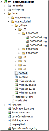
  所以我们可以抛开GetTileUrl,直接重写GetTileSource方法,来根据row,col,level参数,读取地图服务的缓存文件。首先将Exploded格式的地图服务缓存文件拷贝到手机中:

image

  包含conf.cdi(ArcGIS Server 10版本中才有,记录了缓存的全图范围)和conf.xml文件的好处是,我们可以在代码中读取这两个文件来动态生成我们的Tiling Scheme,以完成图层初始化的工作。从配置文件中读取参数后,就可以重写GetTileSource方法了。部分代码如下:

   1: protected override void GetTileSource(int level, int row, int col, Action<System.Windows.Media.ImageSource> onComplete)

   2:         {

   3:             string f = string.Empty;

   4:             if (_cacheTileFormat.ToLower().Contains("png"))

   5:                 f = ".png";

   6:             else if (_cacheTileFormat.ToLower().Contains("jpeg") || _cacheTileFormat.ToLower().Contains("jpg"))

   7:                 f = ".jpg";

   8:             else

   9:                 throw new Exception("切片格式不明:" + _cacheTileFormat);

  10:             #region Exploded读取

  11:             if (_storageFormat == StorageFormat.esriMapCacheStorageModeExploded)

  12:             {

  13:                 string baseUrl = _path;// "/WP_LocalCacheReader;component/Assets/usa_exploded/"

  14:                 baseUrl += @"/_alllayers";

  15:                 string l = "L";

  16:                 l = level.ToString().PadLeft(2, '0');

  17:                 string r = "R";

  18:                 r = String.Format("{0:X}", row).PadLeft(8, '0');

  19:                 string c = "C";

  20:                 c = String.Format("{0:X}", col).PadLeft(8, '0');

  21:                 string str = baseUrl

  22:                     + @"/L" + l

  23:                     + @"/R" + r

  24:                     + @"/C" + c + f;

  25:                 BitmapImage img = new BitmapImage(new Uri(str,UriKind.RelativeOrAbsolute))

  26:                 {

  27:                     CreateOptions = BitmapCreateOptions.DelayCreation

  28:                 };

  29:                 img.ImageFailed += (s, a) =>

  30:                 {

  31:                     string uri = _path + "/missing" + _tileRows.ToString() + f;

  32:                     BitmapImage image = new BitmapImage(new Uri(uri, UriKind.RelativeOrAbsolute))

  33:                     {

  34:                         CreateOptions = BitmapCreateOptions.DelayCreation

  35:                     };

  36:                     onComplete(image);

  37:                     return;

  38:                 };

  39:                 onComplete(img);

  40:             }

  41:             #endregion

  42:         }

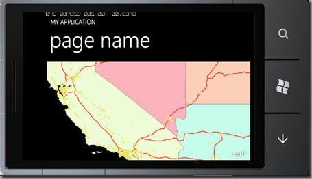
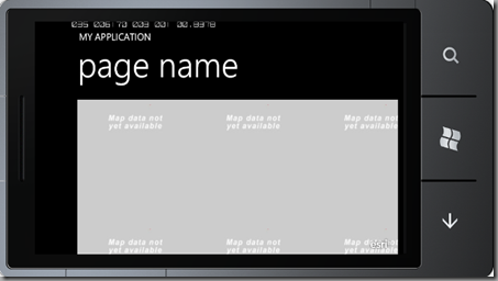
  当指定的切片文件不存在(也许还未创建)时,可以加载事先准备好的missing图片来替换。

2、ArcGIS Server地图服务的Compact格式缓存文件

  这是ArcGIS Server 10推出的新的缓存格式,缓存图片都保存在.bundle文件中,一个bundle目前可存储128*128张切片。切片文件更少,主要目的是为了迁移方便。文档中并未给出读取这种格式文件的方法,不过牛魔王已经凭空推断出了这种格式的内容,这里就借鉴了他的方法。还是先将缓存文件拷贝到手机中:
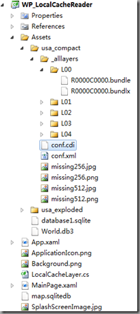
image

  利用conf.cdi和conf.xml获得tiling scheme,之后重写GetTileSource方法。具体思路牛魔王文中已经给出,感兴趣的同学还是看原文,学习牛牛的思路比较好。
  下面是读取两种缓存文件的效果:
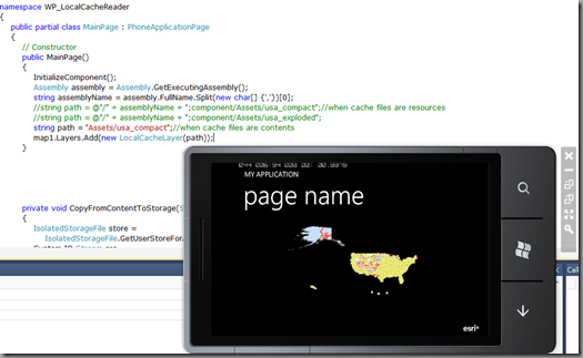
image

image

image

3、第三方离线地图文件

  除了ArcGIS Server的缓存切片之外,我们还可以读取第三方的离线地图文件来做为我们的底图。比如以前面介绍过的Mobile Atlas Creator为例,我现在已经有了很多自己下载好的离线地图,如果能在ArcGIS移动客户端使用起步两全其美?其实在目前的离线导航软件中,很多都用sqlite数据库做为地图存储格式,因为它应用广泛,轻巧,紧凑,Android,iOS,Symbian等系统对它都有原生的支持。Mobile Atlas Creator中,RMaps和OruxMaps都用Sqlite保存离线地图。这里以应用较为广泛的RMaps格式为例,进行试验。
创建好的RMaps地图文件如下:
image

  我们利用FireFox里的Sqlite Manager插件先来查看一下数据库的内容:
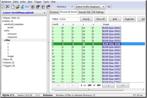
image

  可以看出,我们所需的内容都保存在tiles这张表中,而x,y,z三个参数与我们所需的row,col,level很像。经过试验(保存一个全球范围的地图),很快验证出level=17-z。
  参数有了,要如何读取切片呢?对于Sqlite,虽然目前Windows Phone还没有提供原生的支持,不过codeplex上已经有不少项目都提供了解决办法。我选择Sqlite Client for Windows Phone来读取RMaps的地图文件。下面是RMaps离线地图(Bing Maps)和ArcGIS Online上StreetMap叠加的效果:
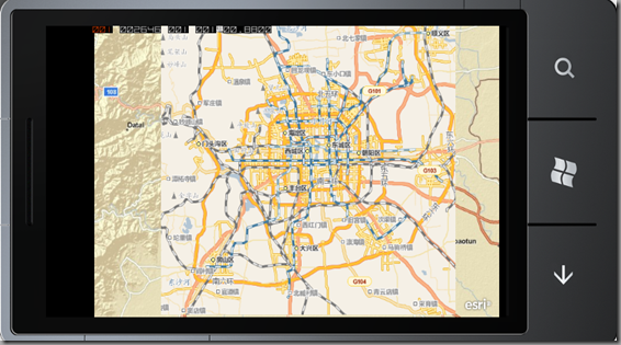
image
  需要说明的是,不论是RMaps还是OruxMaps,都没有在数据库中保存tiling scheme的相关参数,所以我们不能为图层提供诸如FullExtent之类的参数。但这丝毫不影响我们的使用,我们可以为Map控件显示指定Extent,这样就可以直接显示我们的离线地图了。除了自己的地图数据之外,基本上所有数据源都使用一种空间参考,102100或者3857,你懂的。
  这样即使我们没有ArcGIS Server软件,也能制作自己的底图了。这里有网友们已经下载好的各个城市的RMaps格式文件
  相对于RMaps之类的离线地图软件,ArcGIS的移动产品的优势除了不仅能够任意叠加地图数据,还有GraphicsLayer和服务器端强大的功能支持,在配合Windows Phone本身的SDK功能,你也可以做出一个功能全面的导航软件来。

  关于离线地图文件的打包。1、在Silverlight程序中,Build Action的选择决定了文件最后的保存位置,比如你选择Resource,则会嵌入到工程的dll中,如果选择Content,则会保存在dll之外,xap文件之内。以上三种解决方案里,我们可以选择任意的Build Action,这样地图都会通过xap部署到手机里;如果有需要,我们还可以将文件拷贝到程序的IsolatedStorage中去。2、对于Exploded格式的缓存,WP的编程建议中提到,媒体文件Build Action设为Content效率会更高。3、对于Exploded格式的缓存,如果为了拷贝方便,我们也可以将其打包为.zip文件,部署到手机中,在程序加载的时候再将其解压缩来读取。
  本文以ArcGIS for Windows Phone为例,讨论了3种离线底图的解决方案,文中所涉及的所有功能,ArcGIS for iOS和ArcGIS for Android同样适用。

27 thoughts on “ArcGIS移动客户端离线底图的几种解决方案”

  1. Pingback: ArcGIS移动客户端业务数据离线方案的讨论 - 菩提老王的葡萄架

  2. Pingback: ArcGIS移动客户端业务数据离线方案的讨论 « 懒得折腾

  3. Pingback: ArcGIS移动客户端中可以自动离线的底图图层 - 菩提老王的葡萄架

  4. king.wang

    老王,你好:
    我现在开发mobile正需要这个代码,第一次弄mobile的开发,对此不太熟悉,请麻烦你给我传一份这个例子的代码,不胜感激。

    1. 菩提老王 Post Author

      供参考。

      ///

      /// using for ArcGIS Server cache files
      ///

      public class LocalCacheLayer : TiledLayer
      {
      private Envelope _fullExtent;
      private int _wkid;
      private double _originX, _originY;
      private int _tileCols, _tileRows, _dpi;
      private TileInfo _tileInfo;
      private string _cacheTileFormat;
      private enum StorageFormat
      {
      esriMapCacheStorageModeExploded,
      esriMapCacheStorageModeCompact
      }
      private StorageFormat _storageFormat;
      private int _packetSize;
      private string _path;

      ///

      /// using for WPF/WP
      ///

      /// public LocalCacheLayer(string resourcePath)
      {
      _path = resourcePath;// “/WP_LocalCacheReader;component/Assets/usa_compact/”
      Stream cdiStream = App.GetResourceStream(new Uri(resourcePath + “/conf.cdi”, UriKind.RelativeOrAbsolute)).Stream;
      Stream xmlStream = App.GetResourceStream(new Uri(resourcePath + “/conf.xml”, UriKind.RelativeOrAbsolute)).Stream;
      ReadTilingScheme(cdiStream, xmlStream);
      }

      ///

      /// using for WPF/WP
      ///

      /// /// private void ReadTilingScheme(Stream cdiFile, Stream xmlFile)
      {
      //处理cdi文件,读取FullExtent
      double xmin, xmax, ymin, ymax;
      xmin = xmax = ymin = ymax = 0;
      using (XmlReader reader = XmlReader.Create(cdiFile))
      {
      while (reader.Read())
      {
      switch (reader.NodeType)
      {
      case XmlNodeType.Element:
      if (reader.Name == “XMin”)
      xmin = reader.ReadElementContentAsDouble();
      if (reader.Name == “YMin”)
      ymin = reader.ReadElementContentAsDouble();
      if (reader.Name == “XMax”)
      xmax = reader.ReadElementContentAsDouble();
      if (reader.Name == “YMax”)
      ymax = reader.ReadElementContentAsDouble();
      break;
      case XmlNodeType.Text:

      break;
      case XmlNodeType.XmlDeclaration:
      case XmlNodeType.ProcessingInstruction:

      break;
      case XmlNodeType.Comment:

      break;
      case XmlNodeType.EndElement:

      break;
      }
      }
      if (Math.Abs(xmin – 0) > 0.0001)
      _fullExtent = new Envelope(xmin, ymin, xmax, ymax);
      else
      throw new Exception(“读取cdi文件的fullextent出错!”);
      };
      //处理xml文件,读取tiling shceme
      using (XmlReader reader = XmlReader.Create(xmlFile))
      {
      while (reader.Read())
      {
      switch (reader.NodeType)
      {
      case XmlNodeType.Element:
      if (reader.Name == “WKID”)
      {
      _wkid = reader.ReadElementContentAsInt();
      _fullExtent.SpatialReference = new SpatialReference(_wkid);
      }
      if (reader.Name == “TileOrigin”)
      {
      //-400400
      using (XmlReader r = reader.ReadSubtree())
      {
      while (r.Read())
      {
      if (r.Name == “X”)
      _originX = r.ReadElementContentAsDouble();
      if (r.Name == “Y”)
      _originY = r.ReadElementContentAsDouble();
      }
      }
      }
      if (reader.Name == “TileCols”)
      _tileCols = reader.ReadElementContentAsInt();
      if (reader.Name == “TileRows”)
      _tileRows = reader.ReadElementContentAsInt();
      if (reader.Name == “DPI”)
      _dpi = reader.ReadElementContentAsInt();
      if (reader.Name == “LODInfos”)
      {
      //080000000.019035688046642237…..
      //ref:Reading number of elements of a XML using XMLReader http://forums.silverlight.net/forums/p/24245/86996.aspx
      //先读取LODInfo个数
      int count = 0;
      using (XmlReader r = reader.ReadSubtree())
      {
      while (r.Read())
      {
      if (r.NodeType == XmlNodeType.Element && r.Name.Equals(“LODInfo”))
      {
      count++;
      }
      }
      _tileInfo = new TileInfo()
      {
      Height = _tileRows,
      Width = _tileCols,
      Origin = new MapPoint(_originX, _originY) { SpatialReference = new ESRI.ArcGIS.Client.Geometry.SpatialReference(_wkid) },
      Lods = new Lod[count]
      };
      }
      }
      break;
      case XmlNodeType.Text:

      break;
      case XmlNodeType.XmlDeclaration:
      case XmlNodeType.ProcessingInstruction:

      break;
      case XmlNodeType.Comment:

      break;
      case XmlNodeType.EndElement:

      break;
      }
      }
      if (Math.Abs(_tileCols – _tileRows) > 0.0001)
      throw new Exception(“切片不是正方形”);
      if (_dpi > 96)
      throw new Exception(“DPI大于96,异常”);
      };
      //readsubtree后,需要让reader回到lodinfos再次使用,再处理LODInfos其中内容
      xmlFile.Seek(0, SeekOrigin.Begin);
      using (XmlReader reader = XmlReader.Create(xmlFile))
      {
      while (reader.Read())
      {
      if (reader.NodeType == XmlNodeType.Element && reader.Name.Equals(“LODInfos”))
      {
      using (XmlReader r = reader.ReadSubtree())
      {
      while (r.Read())
      {
      //-080000000.019035688046642237
      if (r.NodeType == XmlNodeType.Element && r.Name.Equals(“LODInfo”))
      {
      int levelid = -1;
      double res = -1;
      using (XmlReader rr = r.ReadSubtree())
      {
      while (rr.Read())
      {
      if (rr.NodeType == XmlNodeType.Element && rr.Name.Equals(“LevelID”))
      levelid = rr.ReadElementContentAsInt();
      if (rr.NodeType == XmlNodeType.Element && rr.Name.Equals(“Resolution”))
      res = rr.ReadElementContentAsDouble();
      }
      }
      _tileInfo.Lods[levelid] = new Lod()
      {
      Resolution = res,
      };
      }
      }
      }
      }
      if (reader.NodeType == XmlNodeType.Element && reader.Name.Equals(“CacheTileFormat”))
      _cacheTileFormat = reader.ReadElementContentAsString();
      if (reader.NodeType == XmlNodeType.Element && reader.Name.Equals(“StorageFormat”))
      _storageFormat = (StorageFormat)Enum.Parse(typeof(StorageFormat), reader.ReadElementContentAsString(),true);
      if (reader.NodeType == XmlNodeType.Element && reader.Name.Equals(“PacketSize”))
      _packetSize = reader.ReadElementContentAsInt();
      }
      }
      }

      public override void Initialize()
      {
      this.FullExtent = _fullExtent;
      // This layer’s spatial reference
      this.SpatialReference = new SpatialReference(_wkid);
      // Set up tile information. Each tile is 256x256px, 19 levels.
      this.TileInfo = _tileInfo;
      // Set the resolutions for each level. Each level is half the resolution of the previous one.
      //already done in ReadTilingScheme()
      // Call base initialize to raise the initialization event
      base.Initialize();
      }

      protected override void GetTileSource(int level, int row, int col, Action onComplete)
      {
      string f = string.Empty;
      if (_cacheTileFormat.ToLower().Contains(“png”))
      f = “.png”;
      else if (_cacheTileFormat.ToLower().Contains(“jpeg”) || _cacheTileFormat.ToLower().Contains(“jpg”))
      f = “.jpg”;
      else
      throw new Exception(“切片格式不明:” + _cacheTileFormat);
      #region Exploded读取
      if (_storageFormat == StorageFormat.esriMapCacheStorageModeExploded)
      {
      //string baseUrl = @”d:arcgisserverarcgiscacheinspur_shandong1图层_alllayers”;
      string baseUrl = _path;//D:\arcgisserver\arcgiscache\inspur_shandong1\图层
      baseUrl += @”/_alllayers”;
      string l = “L”;
      l = level.ToString().PadLeft(2, ‘0’);
      string r = “R”;
      r = String.Format(“{0:X}”, row).PadLeft(8, ‘0’);
      string c = “C”;
      c = String.Format(“{0:X}”, col).PadLeft(8, ‘0’);
      string str = baseUrl
      + @”/L” + l
      + @”/R” + r
      + @”/C” + c + f;
      BitmapImage img = new BitmapImage(new Uri(str,UriKind.RelativeOrAbsolute))
      {
      CreateOptions = BitmapCreateOptions.DelayCreation
      };
      img.ImageFailed += (s, a) =>
      {
      string uri = _path + “/missing” + _tileRows.ToString() + f;
      BitmapImage image = new BitmapImage(new Uri(uri, UriKind.RelativeOrAbsolute))
      {
      CreateOptions = BitmapCreateOptions.DelayCreation
      };
      onComplete(image);
      return;
      };
      onComplete(img);
      }
      #endregion
      #region Compact读取
      else
      {

      long num = (col / _packetSize) * _packetSize;
      long num2 = (row / _packetSize) * _packetSize;
      string str = “_alllayers”;
      string str2 = level < 10 ? "L0" + level : "L" + level; string str3 = "C" + Convert.ToInt32(num).ToString("x4"); string str4 = "R" + Convert.ToInt32(num2).ToString("x4"); string baseUrl = _path; string bundlefilename = baseUrl + "/" + str + "/" + str2 + "/" + str4 + str3 + ".bundle"; string bundlxfilename = baseUrl + "/" + str + "/" + str2 + "/" + str4 + str3 + ".bundlx"; try { Stream fs1=App.GetResourceStream(new Uri(bundlefilename, UriKind.RelativeOrAbsolute)).Stream; Stream fs2=App.GetResourceStream(new Uri(bundlxfilename, UriKind.RelativeOrAbsolute)).Stream; } catch { //throw new Exception("bundle或bundlx文件不存在:n" + bundlefilename + "n" + bundlxfilename); string uri = _path + "/missing" + _tileRows.ToString() + f; BitmapImage image = new BitmapImage(new Uri(uri, UriKind.RelativeOrAbsolute)) { CreateOptions = BitmapCreateOptions.DelayCreation }; onComplete(image); return; } try { long tilePosOffset; using (Stream fs = App.GetResourceStream(new Uri(bundlxfilename, UriKind.RelativeOrAbsolute)).Stream) { int bundleRow = row / _packetSize; int bundleCol = col / _packetSize; int tileStartRow = _packetSize * bundleRow; int tileStartCol = _packetSize * bundleCol; int tileNumInBundle = (col - tileStartCol) * 128 + (row - tileStartRow); fs.Seek(16 + tileNumInBundle * 5, SeekOrigin.Begin); byte[] bytes = new byte[5]; fs.Read(bytes, 0, 5); tilePosOffset = GetLongFromBytes(bytes, true); } //在bundle文件中读取tile byte[] imageBytes; using (Stream fs = App.GetResourceStream(new Uri(bundlefilename, UriKind.RelativeOrAbsolute)).Stream) { fs.Seek(tilePosOffset, SeekOrigin.Begin); byte[] tileLengthBytes = new byte[4]; fs.Read(tileLengthBytes, 0, 4); long tileLength = GetLongFromBytes(tileLengthBytes, true); imageBytes = new byte[tileLength]; fs.Read(imageBytes, 0, Convert.ToInt32(tileLength)); } MemoryStream ms = new MemoryStream(imageBytes); BitmapImage img = new BitmapImage() { //CreateOptions = BitmapCreateOptions.DelayCreation, }; img.SetSource(ms); ms.Close(); onComplete(img); } catch (Exception e) { MessageBox.Show(e.Message); } } #endregion } private long GetLongFromBytes(byte[] buf, bool asc) { if (buf == null) { throw new Exception("byte array is null!"); } if (buf.Length > 8)
      {
      throw new Exception(“byte array size > 8 !”);
      }
      long r = 0;
      if (asc)
      for (int i = buf.Length – 1; i >= 0; i–)
      {
      r <<= 8; r |= (buf[i] & (uint)0x00000000000000ff); } else for (int i = 0; i < buf.Length; i++) { r <<= 8; r |= (buf[i] & (uint)0x00000000000000ff); } return r; } }

  5. android中继承TiledServiceLayer ,实现protected byte[] getTile(int lev, int col, int row) 对谷歌地图的访问。这个我怎么也搞不出来。听楼主的意思应该特别简单的,我是新手楼主能否实现以下把代码贴出来。小弟万分感谢。

  6. 我的事例,但是感觉在胡闹,地图根本就不显示。
    package com.esri.arcgis.android.samples.helloworld;

    import java.util.concurrent.RejectedExecutionException;

    import android.util.Log;

    import com.esri.android.map.TiledLayer;
    import com.esri.android.map.TiledServiceLayer;
    import com.esri.core.geometry.Envelope;
    import com.esri.core.geometry.GeometryEngine;
    import com.esri.core.geometry.Point;
    import com.esri.core.geometry.SpatialReference;

    public class CustomTiledMapServiceLayer extends TiledServiceLayer{
    /****/
    private TileInfo _titlinfo;
    private static final double c[] = {
    4891.96981024998D, 2445.98490512499D, 1222.99245256249D, 611.49622628138D, 305.748113140558D, 152.874056570411D, 76.4370282850732D, 38.2185141425366D, 19.1092570712683D, 9.55462853563415D,
    4.77731426794937D
    };
    //scale
    private static final double d[] = {
    18489297.737236D, 9244648.868618D, 4622324.434309D, 2311162.217155D, 1155581.108577D, 577790.554289D, 288895.277144D, 144447.638572D, 72223.819286D, 36111.909643D,
    18055.954822D
    };

    public CustomTiledMapServiceLayer() {
    super(“”);
    Log.v(“ddddddddddd”,”CustomTiledMapServiceLayer”);
    try{
    if (true) {
    try {
    getServiceExecutor().submit(new Runnable() {
    final CustomTiledMapServiceLayer a;
    public final void run() {
    a.initLayer();
    }
    {
    a = CustomTiledMapServiceLayer.this;
    }
    });
    return;
    }
    catch (RejectedExecutionException _ex) { }
    }
    }catch(Exception e){
    e.printStackTrace();
    }
    }

    protected byte[] getTile(int lev, int col, int row) throws Exception {
    Log.v(“ddd”,”getTile”);
    String url = “http://mt”+(col%4)+”.google.cn/vt/lyrs=t@128,r@174000000&hl=zh-CN&gl=cn&src=app&x=”+col+”&y=”+row+”&z=”+lev+”&s=”;
    return url.getBytes();
    }
    @Override
    protected void initLayer() {
    Log.v(“dddddddddd”,”initLayer”);
    try {
    setTileInfo(new com.esri.android.map.TiledServiceLayer.TileInfo(new Point(-20037508.342787D, 20037508.342787D),
    d, c, 11, 96, 256, 256));
    Envelope envelope1 = (Envelope)GeometryEngine.project(getInitialExtent(), SpatialReference.create(102113), SpatialReference.create(102113));
    setInitialExtent(envelope1);
    Envelope envelope = (Envelope)GeometryEngine.project(getInitialExtent(), SpatialReference.create(102113), SpatialReference.create(102113));
    setInitialExtent(envelope);
    this.create();
    super.initLayer();
    return;
    }
    catch (Exception exception) {
    exception.printStackTrace();
    Log.v(“dddddd”,”Exception”);
    }
    }
    /****/
    @Override
    public Envelope getFullExtent() {
    Log.v(“dddd”,”getFullExtent”);
    return new Envelope(-20037508.342787, -20037508.342787, 20037508.342787, 20037508.342787);
    }
    @Override
    protected Envelope getInitialExtent() {
    Log.v(“dddd”,”getInitialExtent”);
    return new Envelope(11505945.4433426, 4033034.1810582, 11772432.8383941, 4320403.23966665);
    }
    @Override
    public SpatialReference getSpatialReference() {
    Log.v(“dddd”,”getSpatialReference”);
    return SpatialReference.create(102113);
    }

    }

  7. 孙小聪

    老师您好,我是一个在校学生,对GIS很感兴趣。现在手机分辨率越来越高,我之前做的切图显示的时候,显示的时候,字都特别小,请问您知道用什么方法可以获取适合高分辨率手机的mbtiles地图数据么?谢谢了。

    1. diligentpig

      1、现在获取mbtiles的地图推荐用这个工具:https://geopbs.codeplex.com/
      2、关于字小问题产生的原因和解决办法见:http://resources.arcgis.com/en/help/windows-phone-sdk/concepts/011v/011v00000013000000.htm

    1. 菩提老王 Post Author

      这个类是一个示例代码,很可能不能直接应用到你的工程中。但里面有了实现的基本思路和关键技术,你可以结合搜索引擎,对立面代码进行理解,之后就好排查为什么你的地图出不来了。

Leave a Comment

Your email address will not be published. Required fields are marked *